
Firemaps, the startup using tech-driven solutions to defend California Homes from wildfire, today announced the general availability of their platform across California. Firemaps uses satellite and drone imagery to create ultra highly accurate 3D maps to analyze properties, create a home hardening and defensible space plan. As fire season bears down on California, Firemaps is bringing speed and efficiency to a process that might otherwise take months to complete. Within three weeks, Firemaps can greatly reduce the risk of a home being destroyed by wildfire, quickly bringing properties into compliance with often extensive insurance and municipal codes. The company has also raised $5.5 million in seed investment led by Andreessen Horowitz and including Uber CEO Dara Khosrowshahi and investor Lee Fixel.
In the June 2021 report from the UC Berkeley Center for Community Innovation and nonpartisan nonprofit think tank Next 10, more than 1 in 12 California homes is located in an area that has a high risk of burning in a wildfire event. At the same time, California is facing an insurance crisis.
Firemaps not only helps homeowners parse insurance requirements, but the platform can also, with the homeowner’s permission, share comprehensive reports. Reinsurers can quickly see what proportion of homes in a given area have been secured against wildfire. State and municipal governments can apply grant dollars apportioned for these treatments back to the homeowner via the platform. Jahan Khanna, CEO of Firemaps, commented:
“As we speak, there are record-breaking wildfires throughout the western half of the USA, as well as in France, Spain, Turkey, Greece, Russia, and in Canada. Wildfire season is now all year. It will continue to threaten the lives of firefighters and destroy homes and communities. There are millions of homes in high-risk areas that need complex work done at an unprecedented scale, as quickly as possible. We created the Firemaps platform as a way to deal with the effects of climate change for the people who have to live with it.”
Firemaps do not charge homeowners a premium. Due to the efficiency of the platform, contractors pay a fee to participate. Homeowners in high-risk areas can get the mapping done for free. Firemaps can also help homeowners procure available grant funding. Qualifying homeowners can use this state grant money to help pay for their Firemaps wildfire defence. Here is how the Firemaps process works:
- Homeowners submit their addresses at Firemaps.com.
- Firemaps uses satellite imagery and machine learning to create a preliminary risk assessment.
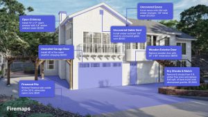
- For high-risk homes, Firemaps will construct a 3D map of their home and property using a handheld drone. The map is able to render details of the home’s landscape, topography, vent construction, deck construction, roof condition, and porch or deck vulnerability and can measure the particular features of the property.
- The map is used to generate a detailed risk assessment and wildfire defence plan, taking into consideration local fire department guidance and homeowner insurance requirements.
- Qualified contractors, arborists, and other tradespeople are able to bid on the work remotely, using the Firemaps data. The Firemaps project manages the process.
- The Firemaps platform can routinely dispatch contractors to keep the work maintained as vegetation regrows, and will allow the property owner to voluntarily share the data with insurance agencies, their local fire departments, and other stakeholders in exchange for insurance discounts and local government incentives or tax credits where applicable.
Firemaps
Study after study shows that this work is not just necessary, but it’s critical in the fight against untamed wildfire:
- An analysis of over 115,000 homes across over 1200 historical fire events in North America shows that these defensible space landscaping techniques can increase the chances of a home surviving a wildfire by up to 90%.
- Hardening the home and replacing roofing, siding, and vents have the potential to add another 50% chance of survivability.
- California State Forestry research indicates communities, where over 70% of the homes in the area have applied both techniques across all homes, have done roughly the equivalent of putting an extra fire break in the surrounding geography to secure the neighbourhood.
Both CALFire and IBHS.org advocate for homeowners to apply these techniques, as do newly introduced CA state regulations and building codes like AB38.